
Deptford ZIP Code Coverage
Postal geography around Deptford has a useful split. The dominant Deptford clue is 08096, served by the Deptford Post Office. Official Deptford-area examples also use Sewell, NJ 08080 on Tanyard Road and Woodbury, NJ 08096 on Cooper Street and Good Intent Road. Those Deptford examples make a strong case for checking the exact delivery point before merging a mailing city with the township. They do not support a claim that a five-digit ZIP is a complete Deptford boundary.
| ZIP | Areas covered | Post office | Notes |
|---|---|---|---|
| 08096 | Primary Deptford postal line; Woodbury mailing lines also occur in official local examples | Deptford Post Office, 1265 Hurffville Road, Deptford NJ 08096-9996 | Dominant local clue. Validate the full address and ZIP+4. |
| 08080 | Deptford-related Tanyard Road has an official polling-place example with a Sewell mailing line | Not identified in the official research | An address lead only, not a complete street crosswalk or township boundary. |
| 08096, Woodbury line | Deptford Cooper Street and Good Intent Road examples appear as Woodbury, NJ 08096 | Same five-digit ZIP; no separate post-office claim was located | Postal city can differ from Deptford Township for an address tied to local records. |
No complete USPS-derived street-to-ZIP crosswalk, unique post-office ZIP, or historical ZIP realignment was located in the Deptford research. That absence matters. A complete-looking table would overstate what the official sources actually establish.
Deptford ZIP Code Postal Clues
Three official address examples show why a Deptford ZIP code search needs more than the town name. The municipal building appears as 1011 Cooper Street, Deptford NJ 08096. A Deptford polling-place example at 1341 Tanyard Road appears as Sewell NJ 08080. Another Deptford official example at 2401 Good Intent Road appears as Woodbury NJ 08096. These Deptford examples are public facility mailing lines, not evidence about nearby households or proof of where a ZIP boundary runs.
The contrast is still useful when comparing records. A tax or deed search can use the township and parcel. A mail label may use a different postal city. A directory entry may use the wording current when it was printed. Preserve each form instead of silently rewriting every address to Deptford. The result is a cleaner trail when a property sits near a postal-line transition or a historical place label.
Deptford ZIP Code USPS Checks
The authoritative next step is the USPS ZIP Code Lookup, which checks a specific Deptford street delivery address. It should be used before treating 08096, 08080, or Woodbury as interchangeable search terms. Save the normalized street, house number, unit if any, postal city, ZIP, ZIP+4, township, county, and the date of the response. USPS delivery data can change, so an old result should not be assumed to remain current.
- Enter the complete known address into the USPS address lookup. Do not start with a five-digit ZIP alone.
- Copy the returned postal city, ZIP, and ZIP+4 exactly as shown, along with the standardized street spelling.
- Compare that result with the township and county stated in the record being researched. Postal city and municipal jurisdiction are separate fields.
- Use the normalized address in the tax portal or parcel viewer, then record the source and date for each return.
The USPS Deptford Post Office listing identifies the 08096 location at 1265 Hurffville Road and gives 856-232-6785 as the contact number. The post-office listing is a source for its own Deptford address and contact, not a list of delivery recipients.
Deptford ZIP Code Post Office
The USPS Deptford Post Office listing is the cited source for this postal-location reference.
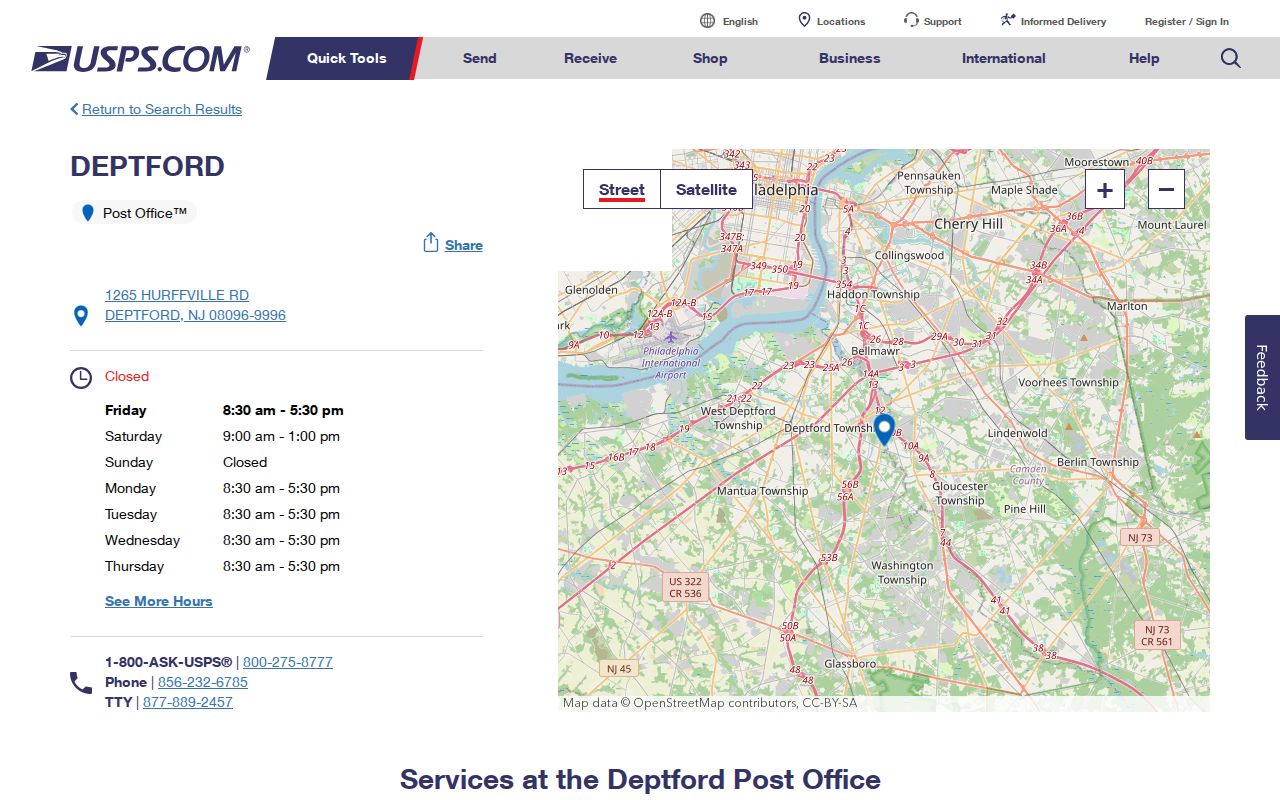
Use the office details to confirm the 08096 postal reference, then use the exact-address lookup to validate a particular delivery point.
Deptford ZIP Code Search Fields
Official local records are not all searchable by ZIP code. The tax portal is organized around Deptford as a municipal district and allows an address or parcel key. NJGIN Property Explorer uses address and parcel fields. Neither source description supports inventing a ZIP filter. Use the fields shown below to turn an exact USPS result into a property or map search, then retain ZIP as a postal attribute rather than a claim about the portal's search options.
| System | Confirmed search fields | ZIP control | Use with a postal result |
|---|---|---|---|
| Gloucester County tax record search | District, House Number, Street Name, Property Owner, Block, Lot, Qualifer | Not shown | Select DEPTFORD and search the normalized house number and street, or use block and lot. |
| NJGIN Property Explorer | Address, county, municipality, block, lot | No ZIP control shown in the authoritative description | Use the USPS-normalized address, then keep ZIP separately in the research note. |
| USPS ZIP Code Lookup | Exact address lookup | Returns a ZIP and ZIP+4 for the address result | Treat the returned delivery data as the postal check. |
The county tax portal does not document a universal data year, and the NJGIN Property Explorer says its parcel composite is maintained from county and municipal sources and is not a legal survey. Capture the displayed source or update information on each result.
Find a Deptford ZIP Code Address
Use a ZIP code to organize an address search, not to promise a ZIP-wide resident list. Start with the full USPS-validated street address. Then select DEPTFORD in the tax search and use house number and street, or the block and lot if known. Check the parcel in NJGIN or county GIS. That sequence respects the fields the portals actually expose and avoids mistaking a postal label for a municipal or parcel filter.
Election material also has limits. The New Jersey voter registration status lookup is an individual status tool using exact name, date of birth, city, and county guidance. It is not a downloadable ZIP directory. A county voter list is a different, statutory route. N.J.S.A. 19:31-18 describes a list arranged by residence number and street, while N.J.S.A. 19:31-18.1 controls copies and bars commercial or charitable solicitation.
Once the postal check narrows work to a particular street, the Deptford street directory explains the address, parcel, deed, and historical-directory sequence. A ZIP alone should not substitute for that street-level verification.
Deptford ZIP Code Election Context
The New Jersey voter-registration information is the source for this record-access reference.
Registration and polling resources can help verify the right election office or facility, but a polling address is an address lead, not proof of who receives mail nearby.
Deptford ZIP Code City Lines
A ZIP code is a mail-delivery designation. Deptford is legally a township in Gloucester County, and postal city lines may use Deptford, Sewell, or Woodbury for addresses associated with local records. A county tax record can identify a Deptford parcel even when its mailing line says Woodbury. Likewise, an 08080 example on Tanyard Road does not by itself redraw the township boundary. Keep postal city, township, county, block and lot, and the source date as separate fields.
- ZIP code and ZIP+4
- A five-digit delivery area and the added four digits USPS returns for a more specific delivery segment or address.
- PO-box ZIP
- A ZIP used for post-office boxes rather than a claim about every street delivery nearby.
- Unique ZIP
- A ZIP assigned to a single organization or destination. No unique Deptford ZIP was located in the official research.
- Carrier route
- A delivery route within postal operations. It is not a municipal boundary or a public household roster.
Note: Exact-address USPS validation is the only supported way to settle a particular Deptford delivery line in the available research.
Deptford ZIP Code Area Context
Census QuickFacts for Deptford Township provides the source for the following geographic-context image.
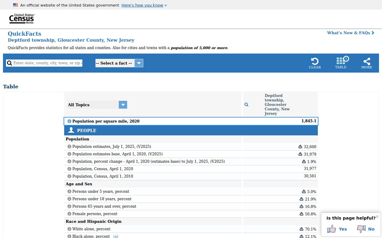
Township population and area data describe Deptford as a whole. They should not be converted into a count for an individual ZIP code, because the researched postal overlap does not provide that crosswalk.
Deptford ZIP Code Historical Geography
Historical directory and land work need different geography rules. A directory-era address may predate the current ZIP system, so do not backfill a modern ZIP onto an old entry without a documented source. Search the place labels used at the time, including Almonesson, Jericho, New Sharon, Oak Valley, and Good Intent. New Sharon was the earlier name adopted in 1917 for the Tanyard and Delsea area after the names Horseheads and Monongahela were used.
Regional Woodbury directory coverage is better supported than a claim of a complete Deptford-only directory. The known runs include 1886, 1909, 1922, 1931-32, 1950, 1952-53, 1955-56, and 1959-60; the final run explicitly includes parts of Deptford, Greenfield Village, and Oak Valley. A historical address should retain its directory year, postal wording if printed, township or section, and page or reel citation.
Deptford ZIP Code Directory Notes
Save a ZIP code result with its source, retrieval date, returned postal city, ZIP+4, address spelling, township, county, and parcel keys where relevant. County tax, GIS, NJGIN, USPS, election, and historical systems each update on their own schedules. NJGIN has reported 2026 parcel geometry updates, while the tax portal and MOD IV do not share that timing. A result should therefore be described by its source and date rather than as simply current.
When an address is copied from a notice, directory, or deed, preserve its original wording before standardizing it for a USPS check. The original form can explain why a Woodbury or Sewell mailing city appears beside a Deptford record. Add the normalized result as a second field, not as a replacement for the dated historical wording.
The Deptford business directory and the county business directory can help compare address spelling and ZIP presentation for an organization. They are not USPS validation and are not resident proof. The safe use is to treat them as a secondary address lead, then verify the delivery line with USPS and the property relationship with the appropriate official record.